| California 58 east & 99 south |
|
Upon merging onto southbound California 99, a reassurance shield assembly shows both California 58 east and California 99 south for the short distance between the Rosedale Highway and Stockdale Highway interchanges. Photo taken 02/13/09. |
| California 58 east |
|
California 58 east leaves southbound California 99 via Exit 24. A two-lane exit transitions traffic from California 99 south to California 58 east, with access to westbound Stockdale Highway at this interchange. Photo taken 02/13/09. |
|
Now on the transition ramp, stay left for California 58 east or merge right for Stockdale Highway west and Brundage Lane. This interchange marks the current western terminus of the California 58 freeway, which extends east from here into the Tehachapi Mountain foothills. Photo taken 02/13/09. |
|
As evidenced by the number of vehicles making the transition from California 99 south to California 58 east, the California 58 freeway is a busy road. California 58 replaces U.S. 466, which used to extend from Bakersfield east to Tehachapi, Mojave, Boron, Barstow, Baker, Las Vegas, Boulder City, and Kingman. With the completion of Interstate 15 and Interstate 40, and with California's elimination of several U.S. highways in 1964, U.S. 466 was removed in stages through the mid-1960s into the 1970s. Owing to its role replacing a former U.S. highway crossing a mountain range, California 58 is still a major east-west highway linking the San Joaquin (Central) Valley with the vast Mojave Desert. Photo taken 02/13/09. |
|
This view looks down from the transition onto the California 58 freeway, which the transition ramp will join shortly. In the distance are the Tehachapi Mountain foothills. Photo taken 02/13/09. |
|
The first exit on the nascent California 58 freeway is Exit 111, H Street and Chester Avenue (0.50 mile). Photo taken 02/13/09. |
|
Now fully merged onto the freeway, this mileage sign provides the distance to the first two exits along California 58 east: Exit 111, H Street and Chester Avenue and Exit 112, California 99 Business (Union Avenue) and California 204 north. Photo taken 02/13/09. |
|
Eastbound California 58 reaches Exit 111, H Street and Chester Avenue. The next interchange along eastbound connects to Exit 112, California 99 Business (Union Avenue) and California 204 north. Photo taken 02/13/09. |
|
The next exit along eastbound California 58 is Exit 112, California 99 Business (Union Avenue) and California 204 north. Photo taken 02/13/09. |
|
Narrowing to two eastbound lanes, this mileage sign provides the distance to the next three exits along California 58 east: Exit 112, California 99 Business (Union Avenue) and California 204 north; Exit 113, Cottonwood Road; and Exit 114, Mount Vernon Avenue. Photo taken 02/13/09. |
|
Union Avenue is the original alignment of U.S. 99 and U.S. 399; today, it is signed as California 99 Business from the southern California 99 interchange at Exit 11 all the way north to downtown Bakersfield and then northwest back to California 99. This is one of the best signed business routes in the state of California. Since the segment of business route between California 58 and California 99 north is state-maintained, it is also designated as California 204. All motorist services are available along Union Avenue. Photo taken 02/13/09. |
|
Eastbound California 58 reaches Exit 112, California 99 Business (Union Avenue) and California 204 north. Photo taken 02/13/09. |
|
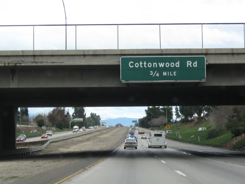
The next exit along California 58 east is Exit 113, Cottonwood Road. Photo taken 02/13/09. |
|
This mileage sign provides the distance to the next three exits along California 58 east: Exit 113, Cottonwood Road; Exit 114, Mount Vernon Avenue; and Exit 115, Oswell Street. Photo taken 02/13/09. |
|
Eastbound California 58 reaches Exit 113, Cottonwood Road in eastern Bakersfield. Photo taken 02/13/09. |
|
The next exit along California 58 east is Exit 114, Mount Vernon Avenue. Photo taken 02/13/09. |
|
A roadside sign advises of the exit number for Exit 114, Mount Vernon Avenue. Photo taken 02/13/09. |
|
This mileage sign provides the distance to the next three exits along California 58 east: Exit 114, Mount Vernon Avenue; Exit 115, Oswell Street; and Exit 116, Fairfax Road. Photo taken 02/13/09. |
|
Eastbound California 58 reaches Exit 114, Mount Vernon Avenue. Photo taken 02/13/09. |
|
The next exit along California 58 east is Exit 115, Oswell Street. Photo taken 02/13/09. |
|
This mileage sign provides the distance to the next three exits along California 58 east: Exit 115, Oswell Street; Exit 116, Fairfax Road; and Exit 117, California 184 (Weedpatch Highway). Photo taken 02/13/09. |
|
Eastbound California 58 reaches Exit 115, Oswell Street. Photo taken 02/13/09. |
|
The next exit along California 58 east is Exit 116, Fairfax Road. Photo taken 02/13/09. |
|
This mileage sign provides the distance to the next three exits along California 58 east: Exit 116, Fairfax Road; Exit 117, California 184 (Weedpatch Highway); and Exit 119, Edison Road to California 58 Business (U.S. 466)/Edison Highway. Photo taken 02/13/09. |
|
Eastbound California 58 reaches Exit 116, Fairfax Road. Photo taken 02/13/09. |
|
The next exit along California 58 east is Exit 117, California 184 (Weedpatch Highway). Photo taken 02/13/09. |
|
California 184 (Weedpatch Highway) travels north along the eastern urban limits of Bakersfield, meeting California 178 northeast of downtown. California 178 then travels northeast into the Kern River Canyon and then continues east into Lake Isabella. Photo taken 02/13/09. |
|
To the south, California 184 travels toward Lamont and Weedpatch, then ends at California 223 (Bear Mountain Road). Weedpatch Highway continues south of California 223, changing into Wheeler Ridge Road to meet Interstate 5 at the Laval Road interchange (Exits 219A-B). Photo taken 02/13/09. |
|
Three single-circuit, 220kV Southern California Edison power lines cross over California 58. These lines carry hydroelectricity generated in the Kern River Canyon and other Sierra Nevada rivers south to the Los Angeles basin. Two sets of these lines parallel Interstate 5 as the freeway passes through the Violin Summit area north of Castaic Junction. Photo taken 02/13/09. |
|
Eastbound California 58 reaches Exit 117, California 184 (Weedpatch Highway). Photo taken 02/13/09. |
|
A fourth and fifth set of single-circuit, 220kV Southern California Edison power lines cross over California 58 at the California 184 (Weedpatch Highway) interchange. Photo taken 02/13/09. |
|
A California 58 east reassurance shield is posted after the on-ramp from California 184 (Weedpatch Highway). Photo taken 02/13/09. |
|
This mileage sign along California 58 east provides the distance to Tehachapi (31 miles), Mojave (53 miles), and Barstow (122 miles). Photo taken 02/13/09. |
|
The next exit along California 58 east is Exit 119, Edison Road. Photo taken 02/13/09. |
|
Eastbound California 58 reaches Exit 119, Edison Road. Use Exit 119 (Edison Road north) to Old Historic U.S. 466 (Edison Highway), which now closely parallels the freeway. Edison Highway was briefly signed as California 58 Business, but all evidence of that designation appears to have been removed. Photo taken 02/13/09. |
|
The next exit along California 58 east is Exit 121, Comanche Drive, which travels south to meet California 223 (Bear Mountain Road) in Arvin. Photo taken 02/13/09. |
|
Spaced about a mile apart, California 58 intersects several of the arterial north-south roads that cross the fertile agricultural area southeast of Bakersfield. Starting with Fairfax Road, the arterials are California 184 (Weedpatch Highway), Vineland Road (no exit), Edison Road, Malaga Road (no exit), Comanche Drive, Tejon Highway (no exit), and Tower Line Road. Photo taken 02/13/09. |
|
Red and white striped water tanks are common sights through the agricultural areas east and south of Bakersfield. Tanks like this one can be found along California 99 and Interstate 5 in the southern San Joaquin Valley. Photo taken 02/13/09. |
|
Eastbound California 58 meets Exit 121, Comanche Drive, which travels south to meet California 223 (Bear Mountain Road) in Arvin. Photo taken 02/13/09. |
|
Passing under the Tejon Highway overpass, the next exit along California 58 east is Exit 123, Tower Line Road (one mile). Photo taken 02/13/09. |
|
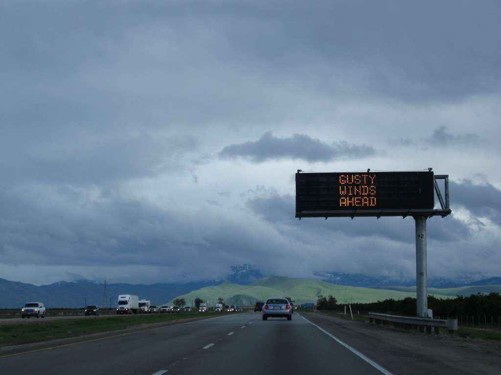
Due to a lingering winter storm, the drive over Tehachapi Summit will bring gusty winds and some remnant snowfall. Unlike Tejon Pass on Interstate 5, which was closed for a portion of this day, California 58 remained open and was able to carry some of Interstate 5's traffic over to the Mojave Desert with the intent of using California 14 for the remaining distance south to Los Angeles. Photo taken 02/13/09. |
|
Eastbound California 58 meets Exit 123, Tower Line Road. Photo taken 02/13/09. |
|
Eastbound California 58 meets Exit 127, General Beale Road. Photo taken 02/13/09. |
|
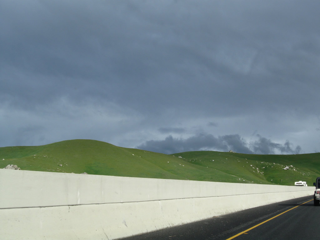
Leaving the flat expanse of the San Joaquin (Central) Valley behind, California 58 sees gorgeous green hills as it starts to gain elevation for its journey to Tehachapi Summit. Green hills here are not terribly common, but after several good winter rainfalls, the hills will show an emerald hue. Recent rains including rain from earlier in the day help bring out the green grass and eventual colorful flowers, especially in the foothills. Photo taken 02/13/09. |
|
This view looks east through the General Beale Road interchange. Photo taken 02/13/09. |
|
A California 58 east reassurance shield is posted after the on-ramp from General Beale Road. Photo taken 02/13/09. |
|
|
|
This suite of photos follows California 58 east as it passes through the Tehachapi Mountains foothills as the freeway skirts past Bear Mountain. The freeway will come to a brief end for two at-grade intersections (both scheduled to be converted to freeway interchanges): Exit 131, California 223 (Bear Mountain Road) west to Arvin and Exit 133, Bealeville Road north to Caliente. Through this segment, the two directions of four-lane California 58 are separated by a Jersey barrier (K-rail), keeping the freeway on a fairly narrow carriageway. Photos taken 02/13/09. |
|
|
|
|
|
|
|
The next exit along California 58 east is Exit 131, California 223 (Bear Mountain Road). California 223 is an east-west state route that travels west from this intersection to Arvin, then intersects California 99 at Exit 13 and ends at Interstate 5 at Exit 239 just east of Buena Vista Recreation Area. Photo taken 02/13/09. |
|
With Interstate 5 closed on this day, California 58 took over a portion of the traffic leading into Southern California. This traffic is visible on California 58 as we look east past the California 223 intersection toward the next uphill grade. During inclement weather that closes Interstate 5, a detour via California 58 east and California 14 south avoids Tejon Pass and allows traffic to connect to Los Angeles (albeit along a longer route). This route is a bit less steep and is the route chosen for the railroads to connect from Northern California to Southern California, including the famous Tehachapi Loop. However, with only two lanes in each direction, the freeway can quickly become overwhelmed with traffic. Photo taken 02/13/09. |
|
As we approach Exit 131, California 223 (Bear Mountain Road), there is a sign for Tejon Ranch. This sprawling ranch consists of 270,000 acres and has holdings in the southern San Joaquin Valley, Tehachapi Mountains, and Antelope Valley. While a portion of the ranch is slated for development (Tejon Mountain Village along Interstate 5 near Lebec, Centennial near the California 138 and Interstate 5 interchange, and the Tejon Industrial Complex near Grapevine), other parts of the ranch are slated for preservation. This came from a pact between the Tejon Ranch Company and several environmental groups signed in June 2008. Photo taken 02/13/09. |
|
Shortly thereafter, eastbound California 58 reaches Exit 131, California 223 (Bear Mountain Road). This at-grade intersection is slated for eventual upgrade to freeway interchange. Photo taken 02/13/09. |
|
The ramp between California 58 east and California 223 (Bear Mountain Road) west appears to be like a freeway off-ramp, but the at-grade intersection lies just beyond it. Photo taken 02/13/09. |
|
A California 58 east reassurance shield is posted next to the "T" intersection with California 223 (Bear Mountain Road). Photo taken 02/13/09. |
|
And wow, that is a lot of traffic heading up the hill to Tehachapi and Mojave. This view is taken after the at-grade intersection with California 223. Photo taken 02/13/09. |
|
A California 58 east reassurance shield is posted after the on-ramp from California 223 east. Photo taken 02/13/09. |
|
|
This view of eastbound California 58 as a divided highway is seen between California 223 and Bealeville Road. Obviously, the Interstate 5 closure in 2009 brought substantially more traffic to this freeway. Photos taken 02/15/04 and 02/13/09. |
|
|
Eastbound California 58 approaches Exit 133, Bealeville Road north to Caliente. This is an at-grade intersection, not an interchange. Photos taken 02/15/04 and 02/13/09. |
|
Bealeville Road is a fairly scenic yet winding and twisting road to Caliente and then north to Lake Isabella. At this intersection, the old alignment of U.S. 466 returns to the freeway. For the next several miles (until Exit 139), U.S. 466 basically follows the current alignment of California 58. Photo taken 02/13/09. |
|
|
The second and final at-grade intersection along eastbound California 58 on the west slope of the Tehachapi Mountains is Exit 133, a left turn to Bealeville Road, which leads north to Caliente, with a connection via Caliente-Bodfish Road to Havilah, Bodfish, and Lake Isabella (California 178). Photos taken 02/15/04 and 02/13/09. |
|
A California 58 east reassurance shield is posted after the Bealeville Road intersection. Photo taken 02/13/09. |
|
The freeway resumes after the Bealeville Road intersection. Photo taken 02/13/09. |
|
Inclement weather can pose difficult travel on California 58; motorists should watch their speed during times of storms or ice. Photo taken 02/13/09. |
|
|
The next exit along California 58 east is Exit 137, Hart Flat Road (one mile). This interchange serves the unincorporated community of Hart Flat. Photos taken 02/13/09 and 02/15/04. |
|
The second exit is Exit 138, Weigh Station for commercial traffic. Photo taken 02/13/09. |
|
Eastbound California 58 reaches Exit 137, Hart Flat Road. Photo taken 02/13/09. |
|
The next exit along California 58 east is Exit 138, Weigh Station. Photo taken 02/13/09. |
|
Eastbound California 58 reaches Exit 138, Weigh Station. Photo taken 02/13/09. |
|
The next exit along California 58 east is Exit 139, U.S. 466/Woodford-Tehachapi Road east to Keene and the Tehachapi Loop. Photo taken 02/13/09. |
|
Use Exit 139 to the National Cesar E. Chavez Center. Photo taken 02/13/09. |
|
Located in the western foothills below Tehachapi Summit, the unincorporated community of Keene is located along the railroad near the Tehachapi Loop. The population was 339 people as of the 2000 Census and the community is located at 2,602 feet. Use Exit 139 to the National Cesar E. Chavez Center (headquarters of the United Farm Workers, a labor union) in Keene. A visitors center and memorial garden are located at the center. Photo taken 02/13/09. |
|
Eastbound California 58 meets Exit 139, Junction Old U.S. 466 east to Keene, the Tehachapi Railroad Loop, and Tehachapi (alternate route to California 58 via a rather narrow two-lane highway to Tehachapi). The next exit along California 58 east is Exit 142, Broome Road. Photo taken 02/13/09. |
|
This mileage sign along California 58 east provides the distance to Tehachapi (California 202, 10 miles), Mojave (California 14, 29 miles), and Barstow (Interstate 15, 97 miles). Photo taken 02/13/09. |
|
California 58 sees some fairly steep climb uphill toward Tehachapi Summit. Photo taken 02/13/09. |
|
The exit number is again posted at the gore point exit number sign. Broome Road passes over the top of California 58 on an overpass visible in the distance ahead. Photo taken 02/13/09. |
|
Between Exits 142 and 148, California 58 sees some relatively sharp curves and continues to gain elevation. The adjacent railroad has a few tunnels that are visible from the freeway. The famed Tehachapi Loop is not visible from the freeway; one must use Old U.S. 466 (Exit 139) to see it. Photo taken 02/13/09. |
|
Green mileposts are in place along California 58 from around the Tehachapi Grade east through to Mojave and Boron. California 58 is the first freeway in California to receive these green mileposts on a pilot basis. Photo taken 02/13/09. |
|
The city of Tehachapi is located at Tehachapi Summit at the highest point of California 58. The city was incorporated in 1909 and had a population of 10,957 people as of the 2000 Census. Most motorist services are available in Tehachapi. One of the largest employers in the city is the California Correctional Facility located at the end of California 202. Photo taken 02/13/09. |
|
Continuing east, the next exit along California 58 is Exit 148, California 202 west and California 58 Business east to Tehachapi (one mile). Photo taken 02/13/09. |
|
The next three exits along eastbound California 58 serve the city of Tehachapi: Exit 148, California 202 west and California 58 Business east; Exit 149, Mill Street; and Exit 151, California 58 Business west. Photo taken 02/13/09. |
|
California 202 west exists primarily to access the correctional facility (prison) located southwest of Tehachapi. Photo taken 02/13/09. |
|
California 58 east approaches Exit 148, California 202 west and California 58 Business east, next right. California 58 Business will follow California 202 south briefly, then follow Old U.S. 466 east into downtown Tehachapi. The business loop reconnects to the freeway at Exit 151. Photo taken 02/13/09. |
|
Just like westbound, only two of the new approach signs along eastbound California 58 for Exit 148 (California 202 west and California 58 Business east) feature the exit number. Photo taken 02/13/09. |
|
Eastbound California 58 meets Exit 148, California 202 west and California 58 Business east. California 202 leads west to the correctional facility, while California 58 Business follows Tehachapi Boulevard through the town. Photo taken 02/13/09. |
|
Snow-covered hills come into view southeast of California 58 as we pass through the California 202 interchange. Photo taken 02/13/09. |
Page Updated August 21, 2010.