| California 55 - Costa Mesa Freeway south |
|
The transition from westbound California 91 (Riverside Freeway) to southbound California 55 (Costa Mesa Freeway) is two lanes located between other ramps. California 55 begins in the city of Anaheim. Founded in 1857 and incorporated on March 18, 1876, Anaheim has a population of 345,556 people (per the 2000 Census) and consists of 50.5 square miles of area. Photo taken 06/23/04. |
|
The first exit along southbound California 55 (Costa Mesa Freeway) is Exit 17, Lincoln Avenue and Nohl Ranch Road. Around this point, California 55 leaves Anaheim and enters the city of Orange. Incorporated on April 6, 1888, Orange had a population of 128,821 as of the 2000 Census. Photo taken 06/23/04. |
|
Southbound California 55 (Costa Mesa Freeway) reaches Exit 17, Lincoln Avenue and Nohl Ranch Road in the city of Orange. Photo taken 06/23/04. |
|
The next exit along southbound California 55 (Costa Mesa Freeway) is Exit 15, Katella Avenue (1.75 miles). Photo taken 06/23/04. |
|
A carpool (high occupancy vehicle) lane begins here in the left lane. Photo taken 06/23/04. |
|
The soundwalls along California 55 in the city of Orange feature mountains laid into the bricks. Photo taken 06/23/04. |
|
This mileage sign along California 55 south provides the distance to the next three exits: Exit 15, Katella Avenue; Exit 14, Chapman Avenue; and Exit 13, California 22 (Garden Grove Freeway). Photo taken 06/23/04. |
|
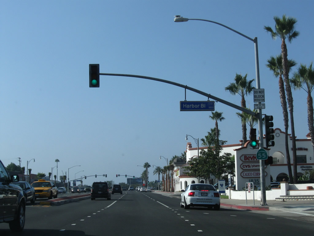
Southbound California 55 reaches Exit 15, Katella Avenue. Photo taken 06/23/04. |
|
The next three exits along southbound are Exit 14, Chapman Avenue; Exit 13, California 22 (Garden Grove Freeway); and Exit 12B, 17th Street. Photo taken 06/23/04. |
|
|
The right lane becomes exit only for Chapman Avenue (Exit 14). An exit number tab was added to this sign between 2004 and 2007. Photos taken 03/25/07 and 06/23/04. |
|
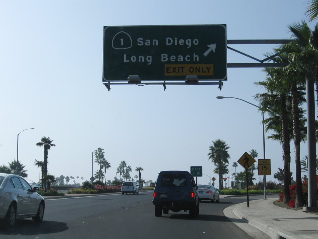
Prior to the off-ramp to Exit 14/Chapman Avenue is this overhead sign assembly for Exit 13, an interchange with California 22 (Garden Grove Freeway) west to Long Beach. Exit 13 marks the eastern terminus of California 22. Photo taken 03/25/07. |
|
Southbound California 55 (Costa Mesa Freeway) reaches Exit 14, Chapman Avenue into the city of Orange. Photo taken 06/23/04. |
|
A roadside sign for Exit 13, California 22 (Garden Grove Freeway) is posted along California 55 south. Photo taken 03/25/07. |
|
The next three exits along southbound are Exit 13, California 22 (Garden Grove Freeway) and Exits 12B-A, 17th Street east to Tustin and west to Santa Ana. Photo taken 06/23/04. |
|
The right lane becomes exit only for westbound California 22. California 22 is a four to eight-lane freeway that connects California 55 (Orange, Tustin, and Santa Ana) with Long Beach via Garden Grove and Westminster. Photo taken 03/25/07. |
|
|
Southbound California 55 (Costa Mesa Freeway) reaches Exit 13, California 22 (Garden Grove Freeway) west to Long Beach. The next exit along southbound is Exits 12B-A, 17th Street. Photos taken 03/25/07 and 06/23/04. |
|
This flyover ramp carries traffic from California 22 east to connects California 55 north. At the California 22 interchange, California 55 leaves the city of Orange and enters the city of Tustin ("Community Trees History Future"). Tustin incorporated in 1927, consists of 11.4 square miles, and was home to 67,504 people as of the 2000 Census. Photo taken 03/25/07. |
|
The next four exits along southbound are California 55 are: Exit 12B, 17th Street west to Santa Ana; Exit 12A, 17th Street east to Tustin; Exit 11B, 4th Street/Irvine Boulevard; and Exit 11A, Interstate 5 (Santa Ana Freeway) south to Irvine. Photo taken 03/25/07. |
|
The next two exits along California 55 (Costa Mesa Freeway) south are Exits 12B-A, 17th Street west and east. Back in 2004, this was the first instance of an exit sign that says "Exits ###B-A" in the exit tab that we've found in California. Now there are plenty of exit number signs of this type statewide as exit numbering continues to expand across the state. Photo taken 03/25/07. |
|
Southbound California 55 (Costa Mesa Freeway) reaches Exit 12B, 17th Street west to Santa Ana; the next ramp is for Exit 12A, 17th Street east to Tustin. Betweens Exits 12B and 11B, California 55 forms the border between Tustin on the east and the city of Santa Ana on the west. Santa Ana sits at an elevation of 135 feet, consists of 27.2 square miles, and receives an average of nearly 13 inches of rainfall annually. Incorporated in 1886, Santa Ana became the seat of Orange County when Orange County split from Los Angeles County in 1889. As of the 2000 Census, Santa Ana had a population of 337,977 people; that number climbed to a total of 353,428 per a 2007 California Department of Finance Estimate. The city is 76% Latino or Hispanic per the 2000 Census, and Santa Ana therefore has one of the nation's largest urban populations of that ethnic group. Photo taken 06/23/04. |
|
Immediately thereafter, California 55 south meets Exit 12A, 17th Street east to Tustin. Photo taken 06/23/04. |
|
This mileage sign provides the distance to the next two exits along California 55 south: Exit 11B, Fourth Street and Irvine Boulevard (0.25 mile) and Exit 11A, Interstate 5 (Santa Ana Freeway) south to Irvine and San Diego (0.50 mile). Photo taken 06/23/04. |
|
Use the right two lanes to reach Exit 11B, Fourth Street and Irvine Boulevard. The three left lanes continue through along southbound California 55, while the number three and four lanes may be used to reach southbound Interstate 5 (Santa Ana Freeway). Photo taken 03/25/07. |
|
Southbound California 55 (Costa Mesa Freeway) meets Exit 11B, Fourth Street west to Santa Ana and Irvine Boulevard southeast to Tustin and Irvine. Photo taken 03/25/07. |
|
Southbound California 55 (Costa Mesa Freeway) reaches Exit 11A, Interstate 5 south to Irvine, San Clemente, and San Diego. Photo taken 06/23/04. |
|
Once on the transition ramp from southbound California 55 to southbound Interstate 5, a ramp for Interstate 5's Exit 102, Newport Boulevard, is posted. Photo taken 06/23/04. |
|
At the end of the transition ramp from southbound California 55, traffic may stay left to merge onto Interstate 5 south or exit right for Exit 102, Newport Boulevard. Photo taken 06/23/04. |
|
This interchange sequence sign provides the distance to the next four exits along California 55 (Costa Mesa Freeway) south: Exit 10, McFadden Street; Exit 9, Edinger Avenue; Exit 8B, Dyer Road west; and Exit 8A, Dyer Road east. Photo taken 03/25/07. |
|
The interchange between California 55 and Interstate 5 is a massive undertaking, with direct access ramps linking the carpool lanes of Interstate 5 with those of California 55. Photo taken 03/25/07. |
|
Each of the next four exits along California 55 (Costa Mesa Freeway) south (Exit 10, McFadden Street; Exit 9, Edinger Avenue; Exit 8B, Dyer Road west; and Exit 8A, Dyer Road east) serve the city of Santa Ana. Photo taken 03/25/07. |
|
After traffic from Interstate 5 south merges onto California 55 south, the right two lanes of California 55 (Costa Mesa Freeway) south become exit only for Exit 10, McFadden Street. Photo taken 03/25/07. |
|
Southbound California 55 (Costa Mesa Freeway) meets Exit 10, McFadden Street. The second exit is Exit 9, Edinger Avenue. Photo taken 03/25/07. |
|
This interchange sequence sign provides the distance to the next four exits along California 55 (Costa Mesa Freeway) south: Exit 9, Edinger Avenue; Exit 8B, Dyer Road west; Exit 8A, Dyer Road east; and Exit 7, MacArthur Boulevard. Photo taken 03/25/07. |
|
Between the McFadden Avenue overpass (just south of Interstate 5) and Warner Avenue, California 55 (Costa Mesa Freeway) straddles the cities of Santa Ana to the west and Tustin to the east. South of Warner Avenue, California 55 will fully enter Santa Ana, the Orange County seat. Photo taken 03/25/07. |
|
Southbound California 55 (Costa Mesa Freeway) reaches Exit 9, Edinger Avenue. The next two exits are Exit 8B, Dyer Road west to Santa Ana and Exit 8A, Dyer Road east, which becomes Barranca Parkway as it enters the nearby city of Irvine. Photo taken 03/25/07. |
|
This interchange sequence sign provides the distance to the next three exits along California 55 (Costa Mesa Freeway) south: Exit 8B, Dyer Road west and Grand Avenue; Exit 8A, Dyer Road east; and Exit 7, MacArthur Boulevard. Photo taken 03/25/07. |
|
Southbound California 55 (Costa Mesa Freeway) reaches Exit 8B, Dyer Road west and Grand Avenue north/south. The next exit is Exit 8A, Dyer Road east to Barranca Parkway. Photo taken 03/25/07. |
|
A set of Southern California Edison 220kV power lines cross over the California 55 freeway near the Dyer Road interchange. Photo taken 03/25/07. |
|
Shortly thereafter, southbound California 55 (Costa Mesa Freeway) reaches Exit 8A, Dyer Road east to Barranca Parkway. Photo taken 03/25/07. |
|
This interchange sequence sign provides the distance to the next three exits along California 55 (Costa Mesa Freeway) south: Exit 7, MacArthur Boulevard; Exit 6B, Interstate 405 (San Diego Freeway) south to San Diego; and Exit 6A, Interstate 405 (San Diego Freeway) north to Long Beach. Photo taken 03/25/07. |
|
Southbound California 55 (Costa Mesa Freeway) reaches Exit 7, MacArthur Boulevard. To the west, MacArthur Boulevard serves Santa Ana. To the east, MacArthur Boulevard leads into the city of Irvine. Home to 143,072 people as of the 2000 Census, Irvine has grown substantially as the city continues to develop. Incorporated on December 28, 1971, Irvine is mostly a master planned community and is home to the University of California at Irvine and the Irvine Spectrum Center nestled between Interstate 5 and Interstate 405. Photo taken 07/03/05. |
|
The next three exits on California 55 south are Exit 6B, Interstate 405 (San Diego Freeway) south to San Diego; Exit 6A, Interstate 405 (San Diego Freeway) north to Long Beach; and Exit 5B, Baker Street. A pair of direct connect ramps (Exits 6D and 6C) leads from the carpool (HOV) lane to both Interstate 405 north and south (left exits). Through Costa Mesa and Irvine, Interstate 405 generally travels northwest-southeast. Photo taken 07/03/05. |
|
|
|
The first ramp (Exit 6D) links the carpool lanes of California 55 south to Interstate 405 (San Diego Freeway) north to Long Beach. This series of pictures follows the ramp from California 55 south to Interstate 405 north; it is a fairly long transition ramp! Photos taken 07/03/05. |
|
|
|
|
|
|
|
The next left ramp is Exit 6C, which links carpool traffic on California 55 south with the HOV lane on Interstate 405 south. Around this point, California 55 leaves Santa Ana and enters the city of Costa Mesa (population 108,724 as of 2000 Census, elevation 98 feet, and incorporated on June 29, 1953). Photo taken 03/25/07. |
|
Southbound California 55 reaches Exit 6C, the direct access ramp to Interstate 405 south for HOV/carpool traffic. The right two lanes connect to Exit 6B, Interstate 405 (San Diego Freeway) south to John Wayne Airport. The second ramp connects to Exit 6A, Interstate 405 north to Long Beach. Photo taken 03/25/07. |
|
|
|
|
This series of pictures shows the transition ramp from California 55's southbound HOV lanes to Interstate 405's southbound HOV lanes (Exit 6C). There is no direct access to John Wayne Airport via this ramp; that connection must be made via Exit 6B. Photos taken 03/25/07. |
|
This interchange sequence sign provides the distance to the next three exits along California 55 (Costa Mesa Freeway) south: Exit 5A, California 73 (Corona del Mar Freeway) south to San Diego; Exit 4, Fair Drive and Del Mar Avenue; and Exit 3, 22nd Street and Victoria Street. Photo taken 10/24/09. |
|
The right lane of California 55 becomes exit only for Exit 5A, California 73 (Corona del Mar Freeway) south to San Diego. California 73 originally opened as the Corona del Mar Freeway in 1978, and it was then extended southeast along the San Joaquin Hills Transportation Corridor (toll road) in 1996. It offers an alternative to Interstate 405 and Interstate 5 through Irvine. Photo taken 10/24/09. |
|
The next two exits along California 55 serve the city of Costa Mesa: Exit 4, Fair Drive and Del Mar Avenue and Exit 3, 22nd Street and Victoria Street. Photo taken 10/24/09. |
|
Southbound California 55 (Costa Mesa Freeway) reaches Exit 5A, California 73 (Corona del Mar Freeway) south to San Diego. Photo taken 10/24/09. |
|
Southbound California 55 (Costa Mesa Freeway) passes through the California 73 stack interchange. Photo taken 10/24/09. |
|
The next exit along California 55 is Exit 4, Fair Drive and Del Mar Avenue. This roadside guide sign is posted prior to teh off-ramp. Photo taken 10/24/09. |
|
The final two exits along California 55's freeway segment are Exit 4, Fair Drive and Del Mar Avenue and Exit 3, 22nd Street and Victoria Street. Photo taken 10/24/09. |
|
Either of the next two exits connect California 55 to the Orange County Fairgrounds. The Orange County Fair is visible in the background, and traffic trying to reach the fair caused some traffic delays. Photo taken 10/24/09. |
|
Southbound California 55 reaches Exit 4, Fair Drive and Del Mar Avenue. The exit number tabs on these signs were pasted onto the overhead signs in late 2003 or early 2004. Photo taken 10/24/09. |
|
This mileage sign provides the distance to the next two exits along California 55 (Costa Mesa Freeway) south: Exit 3, 22nd Street and Victoria Street and Exit 2, 19th Street. Photo taken 10/24/09. |
|
Southbound California 55 reaches Exit 3, 22nd Street and Victoria Street. The freeway ends in another three-quarters of a mile at 19th Street (followed with another traffic signal at its intersection with Harbor Boulevard). Photo taken 10/24/09. |
|
|
|
The freeway goes below grade and approaches its end in about one-half mile. This freeway was planned for continuation south to Newport Beach, but local opposition prevented the freeway from being built over its final mile and a half before reaching California 1. Right of way formerly considered for the freeway in Costa Mesa and Newport Beach is today occupied by commercial establishments and strip malls in Costa Mesa as well as some open space in Newport Beach. Photos taken 10/24/09. |
|
|
|
Southbound California 55 reaches the southern end of the freeway in Costa Mesa. The state route transitions from the sub-grade freeway onto Newport Boulevard, which carries California 55 southwest into the city of Newport Beach, the final destination of California 55. Photos taken 10/24/09. |
|
At the end of the freeway, California 55 meets a traffic signal at 19th Street. As California 55 plies through Costa Mesa, it will pass by a variety of traffic signals before entering the city of Newport Beach. To see original California 55, follow signs for Old Newport Boulevard. Photo taken 05/30/04. |
|
Southbound California 55 shifts from the Costa Mesa Freeway onto Newport Boulevard. This major arterial will carry the state route southwest through southern Costa Mesa into Newport Beach. Photo taken 10/24/09. |
| California 55 - Newport Boulevard south |
|
The first traffic signal on California 55 (Newport Boulevard) is with 19th Street. Photo taken 10/24/09. |
|
A California 55 south reassurance shield is posted along southbound Newport Boulevard at the Harbor Boulevard traffic signal. Photo taken 10/24/09. |
|
After the Industrial Way and 16th Street intersection, California 55 (Newport Boulevard) leaves Costa Mesa and enters the city of Newport Beach (population 70,032 as of 2000 Census and incorporated September 1, 1906). Photo taken 10/24/09. |
|
A final California 55 south reassurance shield is posted on the traffic signal found at the intersection with Hospital Road. Photo taken 10/24/09. |
|
Despite a long arterial section between 19th Street and California 1 (Coast Highway), the final junction between California 55 and California 1 is an interchange. Access to both California 1 north to Long Beach and south to San Diego is made via Exit 1. In Newport Beach, California 1 is designated as Coast Highway; however, it is known as Pacific Coast Highway in Huntington Beach (the next city to the northwest). Photo taken 10/24/09. |
|
California 55 finally reaches Exit 1, California 1. This marks the southern terminus of California 55. Continuing straight ahead leads to city hall, the civic center, and the Balboa Island area of Newport Beach. Photo taken 10/24/09. |
|
Now on the off-ramp from California 55 south to California 1, the left lane will turn to California 1 south to San Diego, while the right lane follows California 1 north to Huntington Beach and Long Beach. Photo taken 10/24/09. |
|
The traffic flow between California 55 and California 1 is governed by a traffic signal. Photo taken 10/24/09. |
Page Updated September 16, 2010.