| California 12 west |
|
A few miles after departing from California 88 near Lockeford, westbound California 12 enters the city of Lodi, the "Zinfandel Capital of the World." Home to 56,999 people as of the 2000 Census, Lodi consists of 12.3 square miles and sits at an elevation of 49 feet. The city incorporated on December 6, 1906. Photo taken 11/23/06. |
|
Westbound California 12 approaches Cluff Avenue. Photo taken 11/23/06. |
|
Soon after the Cluff Avenue intersection, westbound California 12 approaches California 99. Use California 99 north to Sacramento and south to Stockton, Modesto, Fresno, Bakersfield, and Los Angeles. Turn left ahead for a loop ramp onto California 99 north. Photo taken 11/23/06. |
|
After crossing over the California 99 freeway, the next left connects to California 99 south and California 12. The two routes share freeway alignment for a few miles, then California 12 resumes its journey west toward Rio Vista (in the Delta) and Fairfield. Ahead, Victor Road (Old California 12) will proceed west to meet California 99 Business (Cherokee Lane) in Lodi. Turn left here for the brief shared alignment between California 99 and California 12. Photo taken 11/23/06. |
|
Almost immediately upon leaving California 99, westbound California 12 (Kettleman Lane) meets California 99 Business (Cherokee Lane )in Lodi. Photo taken 11/23/06. |
|
Westbound California 12 (Kettleman Lane) meets Stockton Avenue at this traffic signal. Photo taken 11/23/06. |
|
California 12 (Kettleman Lane) approaches San Joaquin County J-3 (Hutchins Street) south to Stockton and north to Lodi. Photo taken 11/23/06. |
|
This view looks west along California 12 between Ham Lane and Lower Sacramento Road. Residences and businesses line California 12. Photo taken 11/23/06. |
|
Westbound California 12 meets San Joaquin County J-10 (Lower Sacramento Road). After this intersection, California 12 leaves the urbanized area around Lodi and passes through farmland. Continuing development pressures may bring more houses west along the California 12 corridor. Photo taken 11/23/06. |
|
Leaving Lodi, California 12 reduces to a two-lane conventional highway. The upcoming 21-mile segment is a headlights-on-for-safety zone. Photo taken 11/23/06. |
|
|
Westbound California 12 approaches San Joaquin County J-8 (Thornton Road). Turn right to follow CR J-8 north to Thornton or turn left to follow Star Street to CR J-8 south to Stockton. The intersection with CR J-8 was realignment to accommodate a truck stop. Photos taken 11/23/06. |
|
|
Immediately thereafter, California 12 west approaches Interstate 5. The first right connects to Interstate 5 north to Sacramento and Redding, while the second right links to Interstate 5 south to Stockton, Tracy, and Los Angeles. Photos taken 11/23/06. |
|
|
|
Two-lane California 12 is a safety corridor with a fairly high amount of traffic. Photo taken 11/23/06. |
|
This mileage sign provides the distance to Rio Vista (14 miles) and Fairfield (38 miles). Photo taken 11/23/06. |
|
California 12 enters the unincorporated community of Terminous, which is where California 12 crosses the Little Potato Slough and enters Bouldin Island. Photo taken 11/23/06. |
|
|
|
The Little Potato Slough Bridge was constructed in 1991 and carries California 12 from the mainland onto Bouldin Island. Photos taken 11/23/06. |
|
The flats of Bouldin Island come into view as California 12 leaves the Little Potato Slough Bridge. Photo taken 11/23/06. |
|
|
|
Eastbound California 12 is flat and straight along Bouldin Island. Photos taken 11/23/06. |
|
|
|
Leaving Bouldin Island, westbound California 12 crosses the Mokelumne River on this 1942 swing bridge. When large boats and ships approach the bridge, the bridge can swing open to allow passage. California 12 leaves San Joaquin County and enters Sacramento County. Photos taken 11/23/06. |
|
Now on Brannan Island in Sacramento County, westbound California 12 approaches the Delta Loop recreation area. Photo taken 11/23/06. |
|
Westbound California 12 approaches Brannan Island Road. Photo taken 11/23/06. |
|
Soon thereafter, California 12 meets Terminous Road northwest to Isleton. Continue straight ahead to follow California 12 west to Rio Vista. Photo taken 11/23/06. |
|
Westbound California 12 approaches Jackson Slough Road. Photo taken 11/23/06. |
|
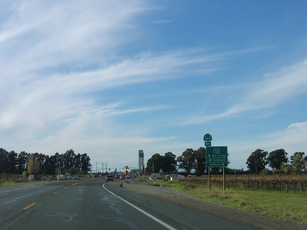
Nearing the western edge of Brannan Island, westbound California 12 approaches California 160 (River Road). California 160 travels north to Isleton, Freeport, and Sacramento. To the south, California 160 travels to Antioch via Sherman Island. Photo taken 11/23/06. |
|
|
|
|
After the intersection with California 160 (River Road), westbound California 12 leaves Brannan Island and crosses the Sacramento River via the Helen Madere Memorial Bridge (built in 1944). This long bridge is a lift bridge that allows large boats and ships to pass underneath it while in operation. When the lift bridge is in operation, the delays to use the bridge can be extensive. California 12 leaves Sacramento County and enters Solano County. Photos taken 11/23/06. |
|
|
|
|
|
Leaving the Madere Bridge, westbound California 12 approaches an interchange with California 84 north to downtown Rio Vista and Ryer Island. This section of California 84 is less well known than the portion signed in the Bay Area south of here. California 84 travels north generally along the west bank of the Sacramento River to end in West Sacramento. Photo taken 11/23/06. |
|
Westbound California 12 meets California 84 in Rio Vista. California 84 is not signed from California 12 along westbound, but it is signed along eastbound California 12. There are reassurance shields along California 84 itself, however. From here, California 12 travels west past California 113 to meet Interstate 80 in Fairfield. Photo taken 11/23/06. |
|
Now on the off-ramp from California 12 west to California 84, a left turn connects to California 84 north, while a right turn connects to California 84 south. Photo taken 11/23/06. |
|
A California 84 trailblazer is posted at the end of the off-ramp. Photo taken 11/23/06. |
|
Back on the mainline and upon leaving Rio Vista, we find this California 12 west reassurance shield along with a mileage sign that provides the distance to Fairfield (21 miles), Vallejo (39 miles), and Napa (41 miles). Photo taken 12/31/04. |
|
Westbound California 12 approaches the turnoff for California 113 north to Dixon, Davis, Woodland, and Yuba City. Photo taken 12/31/04. |
|
California 12 west merges with Interstate 80, then splits from the freeway at Exit 39A and leads into Jameson Canyon. Although the route carries a great deal of traffic as the primary route from Interstate 80 to Napa, California 12 has only two lanes. Photo taken 05/25/06. |
|
The first turn off from California 12 west in Jameson Canyon (between Interstate 80 and California 29) is Red Top Road. Photo taken 05/25/06. |
|
This mileage sign provides the distance to Napa (11 miles), Sonoma (22 miles), and Santa Rosa (43 miles). Allot at least an hour and a half to travel the distance from Interstate 80 to Santa Rosa due to the winding route California 12 takes through the Valley of the Moon. Photo taken 05/25/06. |
|
Lush green hills dominate the view in Jameson Canyon as California 12 continues west toward Napa. Photo taken 05/25/06. |
|
Falling rock and debris can be a problem as the highway passes through small rock cuts such as this one. Photo taken 05/25/06. |
|
An extra wide painted median is used to dissuade passing on a double yellow. Photo taken 05/25/06. |
|
Leaving Solano County, westbound California 12 enters Napa County. Photo taken 05/25/06. |
|
The next traffic signal along westbound California 12 is for Kirkland Ranch Road. Photo taken 05/25/06. |
|
Old California 29 south of Napa is known as Kelly Road, and it is the next traffic signal found along westbound California 12. Photo taken 05/25/06. |
|
Westbound California 12 meets California 29 at the next traffic signal. Turn right to follow California 12 west and California 29 north to Napa. The combined highway carries a great deal of traffic, but the route is built to expressway standards and has a traffic signal at its junction with California 221 (Soscol Avenue). Photo taken 05/25/06. |
|
After splitting from California 121 (Carneros Highway), westbound California 12 follows a two-lane alignment toward Sonoma and the Valley of the Moon. Photo taken 05/25/06. |
|
California 12 is known as the Valley of the Moon Scenic Route as it passes through Sonoma and travels through the crescent-shaped Valley of the Moon. Photo taken 05/25/06. |
|
After a 90-degree turn, California 12 travels northwest toward Sonoma. Photo taken 05/25/06. |
|
Skipping ahead to Santa Rosa and now traveling west on the Hoen Frontage Road, a ramp leads onto westbound California 12. This right of way was slated for a continuation of the California 12 freeway from Hoen Avenue west to Farmers Lane, but as yet, no freeway extension has been constructed. Photo taken 05/25/06. |
|
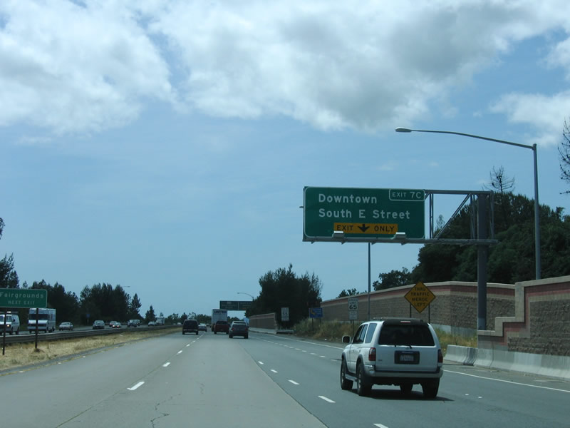
The first exit on westbound California 12 freeway is Exit 7C, South E Street to downtown Santa Rosa. The city of Santa Rosa is the seat of Sonoma County. Incorporated in 1868, Santa Rosa was home to Luther Burbank, a world-renowned horticulturist. Mr. Burbank introduced hundreds of plants in the region during his 50-year stay in Santa Rosa, until his death in 1926. Luther Burbank's home and gardens are preserved near downtown Santa Rosa, and are a national historic landmark. Photo taken 05/25/06. |
|
The freeway gains two new lanes as traffic from California 12 (Farmers Lane) joins the nascent freeway. Photo taken 05/25/06. |
|
The right lane becomes exit only for Exit 7C, South E Street. The left two lanes continues west on California 12 to U.S. 101 and Sebastopol. Photo taken 05/25/06. |
|
Westbound California 12 (Luther Burbank Highway) reaches Exit 7C, South E Street. The next exit is Exits 7B-A, U.S. 101 (Redwood Highway) north and south. Photo taken 05/25/06. |
|
The right lane of California 12 west is exit only for Exit 7B, U.S. 101 (Redwood Highway) north to Ukiah and Eureka. The left two lanes continue west on California 12 to Sebastopol; the next exit is Exit 7A, U.S. 101 (Redwood Highway) south to San Francisco. Photo taken 05/25/06. |
|
Westbound California 12 (Luther Burbank Highway) reaches Exit 7A, U.S. 101 (Redwood Highway) south to San Rafael and San Francisco. The next exit on westbound California 12 is Exit 6, Dutton Avenue. Photo taken 05/25/06. |
|
After the interchange with Exit 6, Dutton Avenue (not shown), the following interchange is Exit 5, Stony Point Road. Photo taken 07/06/13. |
|
Westbound California 12 (Luther Burbank Highway) reaches Exit 5, Stony Point Road. Photo taken 07/06/13. |
|
Passing under Stony Point Road, the next intersection along California 12 west will be Exit 4, Fulton Road (1.25 miles). The meeting of California 12 and Fulton Road is an at-grade, signalized intersection (not an interchange) and marks the western terminus of the freeway segment of California 12 in the vicinity of Santa Rosa. Photo taken 07/06/13. |
|
End Freeway advance signs are posted one-half mile prior to the Fulton Road signalized intersection. Photo taken 07/06/13. |
|
The true end of the freeway is located just before Fulton Road. Photo taken 07/06/13. |
|
Skipping ahead and now entering downtown Sebastopol, westbound California 12 comes to an end at its junction with California 116. Follow California 116 southeast to Petaluma and San Francisco or northwest to Guerneville and Jenner. Photo taken by Trevor Carrier (04/09/07). |
Page Updated September 22, 2013.