

California 2 East
| California 2 east) | |
|---|---|
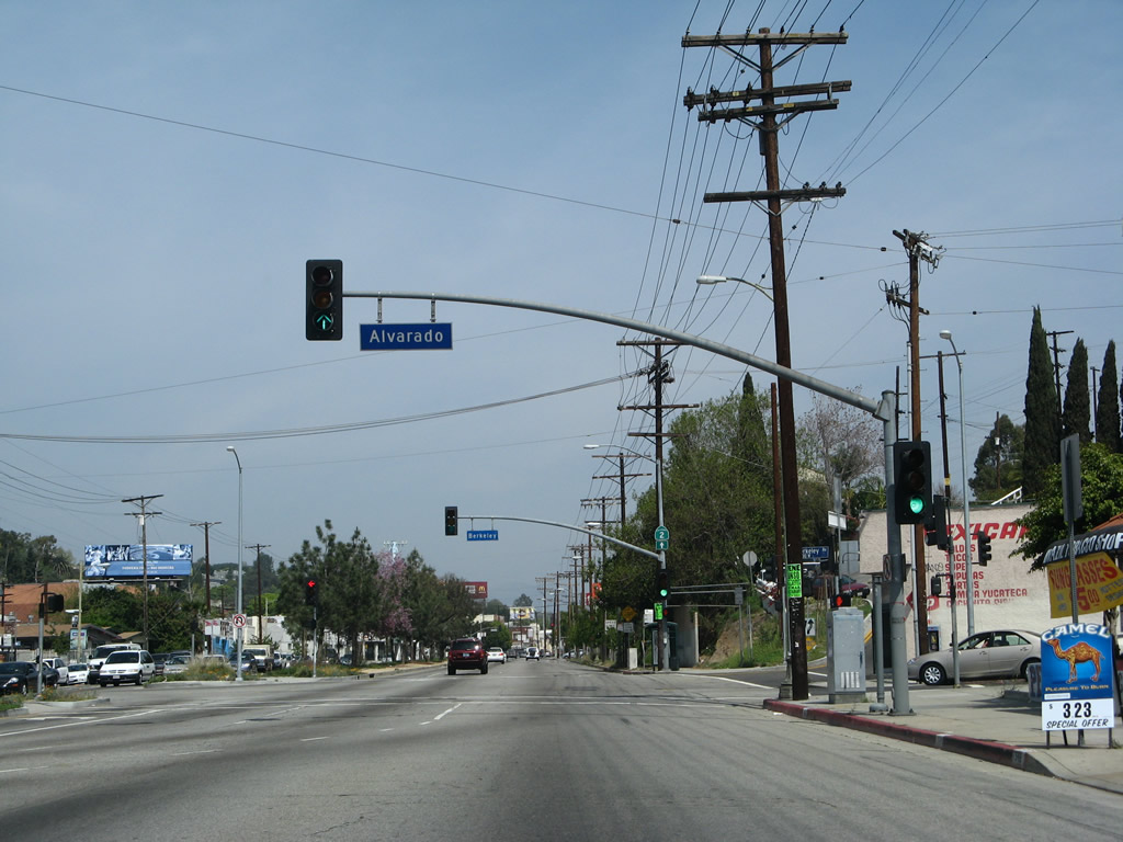 |
California 2 shifts from northbound Alvarado Street to northbound Glendale Boulevard at this traffic signal in the Echo Park district of Los Angeles. Photo taken 03/25/07. |
 |
A California 2 shield is posted on the traffic signal mast arm for Berkeley Avenue. Photo taken 03/25/07. |
 |
Three lanes carry California 2 north on Glendale Boulevard. Photo taken 03/25/07. |
 |
Eastbound (northbound) California 2 meets Aaron Street at this signalized intersection. Photo taken 03/25/07. |
 |
 |
The interchange between Glendale Boulevard and California 2 (Glendale Freeway) comes into view, including the ramp from California 2 south to Glendale Boulevard south. On the left side of the roadway is the Tommy Lasorda Field of Dreams. Photos taken 03/25/07. |
 |
Eastbound California 2 (Glendale Boulevard) meets Allesandro Street at this traffic signal in the Echo Park district of Los Angeles. Allesandro Street parallels the California 2 freeway toward the northeast, connecting with Riverside Drive in the shadow of its interchange with Interstate 5. Through traffic on California 2 should merge right to transition onto California 2 (Glendale Freeway) east (north). Photo taken 03/25/07. |
 |
An overhead sign advises of the connection from Glendale Boulevard to the Glendale Freeway for California 2 east (north). The freeway segment of California 2 travels almost due north from here, even though it is signed as either east or north. Photo taken 03/25/07. |
 |
An unused bridge crosses over Glendale Boulevard, along with the transition ramp from southbound Glendale Freeway to southbound Glendale Boulevard. The unused bridge would have taken the Glendale Freeway further southwest, ultimately connecting with U.S. 101. Now unused, it stands as a reminder for a freeway that would have continued but now is a stub that will likely never be extended as a freeway. The Tommy Lasorda Field of Dreams sits on unused freeway rights of way on the west side of the unused bridge. Photo taken 03/25/07. |
 |
Looking from Allesandro Street, this view shows the southwestern terminus of the Glendale Freeway at Glendale Boulevard looking north. Photo taken 03/25/07. |
 |
A pair of freeway entrance shields straddle the on-ramp from Glendale Boulevard to the Glendale Freeway. Although marked as California 2 north here, this freeway is also occasionally marked as California 2 east. Photo taken 03/25/07. |
 |
The Glendale Freeway begins with two northbound lanes and will quickly widen to four northbound lanes. The first interchange on California 2 north will be with Interstate 5 (Golden State Freeway). Photo taken 03/25/07. |
 |
Northbound (eastbound) California 2 (Glendale Freeway) approaches Exit 13, Interstate 5 (Golden State Freeway). Stay right for the connection to Interstate 5 south to East Los Angeles, Santa Ana, Irvine, and San Diego. Stay left for Interstate 5 north to Burbank, San Fernando Valley, and points north (Central Valley, Bakersfield, Sacramento, and San Francisco). The exit numbers begin at 13, since California 2 begins in Santa Monica (or at least it did, until sections of the route were removed from the state highway system in Santa Monica and West Los Angeles). Photo taken 03/25/07. |
 |
Use Exit 13 to Riverside Drive, which parallels both Interstate 5 and the west bank of the Los Angeles River through here. Photo taken 03/25/07. |
 |
Northbound (eastbound) California 2 (Glendale Freeway) meets Exit 13, Interstate 5 (Golden State Freeway). Photo taken 03/25/07. |
 |
An older, porcelain enamel guide sign is posted on the off-ramp to Interstate 5 (Golden State Freeway) north to Sacramento and south to Santa Ana and San Diego. Photo taken 03/25/07. |
 |
While passing through the Interstate 5 interchange, this mileage sign advises of the next three exits along California 2 (Glendale Freeway): Exit 14, San Fernando Road (old U.S. 6-99); Exit 15, Verdugo Road and Eagle Rock Boulevard; and Exit 16, Colorado Boulevard and Broadway. U.S. 99, the Main Street of California, used to extend from Calexico north to the Oregon border near Yreka until it was decommissioned in stages beginning in 1964. In the greater Los Angeles area, U.S. 99 was replaced by Interstate 10 from Indio west to downtown Los Angeles and by Interstate 5 from downtown north to Wheeler Ridge, where it split off onto California 99. U.S. 6 was also eliminated from Los Angeles in 1964, and it now terminates in Bishop where it meets U.S. 395 in the Eastern Sierra. Remnants of the old road include San Fernando Road, which used to carry both U.S. 6 and U.S. 99 from the north into Los Angeles. Photo taken 03/25/07. |
 |
California 2 passes over Interstate 5. Additional lanes from Interstate 5 merge onto California 2. This interchange was built in 1961-1962. Photo taken 03/25/07. |
 |
A California 2 north (west) reassurance shield is posted as the first of two transition ramps from Interstate 5 join the northbound California 2 freeway. Photo taken 03/25/07. |
 |
A second California 2 shield is posted after another Interstate 5 transition ramp joins the freeway. Photo taken 03/25/07. |
 |
And then a third California 2 shield follows as traffic from Interstate 5 merges onto the Glendale Freeway. Photo taken 03/25/07. |
 |
The next exit is Exit 14, San Fernando Road (old U.S. 6-99) (former Business Loop I-5). U.S. 99 followed San Fernando Road until the Golden State Freeway opened in stages through the late 1950s and early 1960s. As the freeway opened, the old alignment on San Fernando Road was redesignated as U.S. 6-99 Business. When both U.S. 6 and U.S. 99 were eliminated in Los Angeles in the mid-1960s, the old alignment was renumbered as Business Loop I-5. The business designation was retired in the late 1980s as most know the historic route as San Fernando Road without any additional route number. Photo taken 03/25/07. |
 |
A triple-circuit power transmission line operated by Los Angeles Department of Water and Power passes over California 2. Photo taken 03/25/07. |
 |
Northbound (eastbound) California 2 meets Exit 14, San Fernando Road (old U.S. 6-99) (former Business Loop I-5). The section of California 2 between San Fernando Road and California 134 was built in 1976. Photo taken 03/25/07. |
 |
The next exit along California 2 (Glendale Freeway) north (east) is Exit 15, Verdugo Road and Eagle Rock Boulevard. Photo taken 03/25/07. |
 |
This mileage sign advises of the next four exits along California 2 (Glendale Freeway) north (east): Exit 15, Verdugo Road; Exit 16, Colorado Boulevard and Broadway; and Exits 17A-B, California 134 (Ventura Freeway). Photo taken 03/25/07. |
 |
A roadside guide sign provides the distance to Exit 15, Verdugo Road and Eagle Rock Boulevard. Photo taken 03/25/07. |
 |
Northbound (eastbound) California 2 (Glendale Freeway) meets Exit 15, Verdugo Road and Eagle Rock Boulevard. Photo taken 03/25/07. |
 |
A California 2 north (west) reassurance shield is posted after the on-ramp from Verdugo Road. Photo taken 03/25/07. |
 |
The next exit along California 2 (Glendale Freeway) north (east) is Exit 16, Colorado Boulevard and Broadway. Prior to the completion of the Ventura Freeway, California 134 was previously routed along Colorado Boulevard. Photo taken 03/25/07. |
 |
This mileage sign advises of the next three exits along California 2 (Glendale Freeway) north (east): Exit 16, Colorado Boulevard and Broadway and Exits 17A-B, California 134 (Ventura Freeway). Photo taken 03/25/07. |
 |
Use the right two lanes of California 2 (Glendale Freeway) north (east) to connect to Exits 17A-B, California 134 (Ventura Freeway). California 134 travels west to U.S. 101 (Ventura Freeway) west to Ventura and Santa Barbara. To the east, California 134 connects with Interstate 210 (Foothill Freeway) in Pasadena. Interstate 210 then continues east toward San Bernardino and Redlands. Photo taken 03/25/07. |
 |
Northbound California 2 (Glendale Freeway) reaches Exit 16, Colorado Boulevard and Broadway. Use this exit to downtown Glendale. The next interchange is Exits 17A-B, California 134 (Ventura Freeway). This is a stack interchange built in 1971. California 134 is an east-west freeway that connects with California 170 and U.S. 101 to the west near Hollywood and with Interstate 210 and the California 710 stub in the east in Pasadena near the Rose Bowl. Photo taken 03/25/07. |
 |
This view looks north from the Exit 16 gore point toward the California 134 stack interchange. While California 2 remains in Los Angeles until after the stack interchange with California 134, it skirts the eastern edge of Glendale. Photo taken 03/25/07. |
 |
Northbound California 2 (Glendale Freeway) reaches Exit 17A, California 134 (Ventura Freeway) east to Pasadena and San Bernardino. Photo taken 03/25/07. |
 |
Immediately thereafter, northbound California 2 (Glendale Freeway) meets Exit 17B, California 134 (Ventura Freeway) west to Ventura and Santa Barbara. The following exit is Exit 17C, Holly Drive. Photo taken 03/25/07. |
 |
California 2 begins to gain elevation as it continues north toward La Canada-Flintridge. Photo taken 03/25/07. |
 |
The next exit along California 2 (Glendale Freeway) north (east) is Exit 17C, Holly Drive. Photo taken 03/25/07. |
 |
As we meet the gore point for Exit 17C, a very tall flyover ramp crosses over the freeway carrying traffic from California 134 east to California 2 north. Photo taken 03/25/07. |
 |
California 2 leaves Los Angeles and enters the city of Glendale (population 194,973 as of 2000 Census and incorporated on February 15, 1906). Photo taken 03/25/07. |
 |
The next exit along California 2 (Glendale Freeway) north (east) is Exit 18, Mountain Street (0.75 mile). Photo taken 03/25/07. |
 |
The section of California 2 (Glendale Freeway) between California 134 and Interstate 210 is also known as the Frank Lanterman Freeway. Photo taken 03/25/07. |
 |
This mileage sign advises of the final four exits along California 2 (Glendale Freeway) north (east): Exit 18, Mountain Street; Exit 21A, Interstate 210 (Foothill Freeway) east to Pasadena; Exit 21B, Interstate 210 (Foothill Freeway) west to San Fernando and Sacramento (left exit); and Exit 21C, Foothill Boulevard (former California 118). Photo taken 03/25/07. |
 |
Use Exit 18, Mountain Street to Glendale College. Photo taken 09/29/07. |
 |
Northbound (eastbound) California 2 (Glendale Freeway) meets Exit 18, Mountain Street. Photo taken 07/15/09. |
 |
The California 2 (Glendale Freeway) passes under Mountain Street. Photo taken 09/29/07. |
 |
This view looks north along California 2 (Glendale Freeway) from the Mountain Street and Camino San Rafael overpass in Glendale. Photo taken 05/15/10 by Martin Grahl. |
 |
A California 2 north reassurance shield is posted after the on-ramp from Mountain Street. Photo taken 09/29/07. |
 |
Another mileage sign provides the distance to the final three exits along California 2 (Glendale Freeway) north (east): Exit 21A, Interstate 210 (Foothill Freeway) east to Pasadena and California 2 east to Angeles Crest Highway; Exit 21B, Interstate 210 (Foothill Freeway) west to San Fernando and Sacramento (left exit); and Exit 21C, Foothill Boulevard (former California 118). Photo taken 07/15/09. |
 |
A Southern California Edison power transmission line passes overhead as California 2 proceeds through Glendale toward La Canada Flintridge. Photo taken 03/25/07. |
 |
Exits 20A-B-C represents the final interchange along California 2 (Glendale Freeway) north. Through traffic for California 2 north (east) should follow Exit 20A (Interstate 210 east). Photo taken 09/29/07. |
 |
Use Exit 20B to Verdugo Boulevard. Photo taken 09/29/07. |
 |
California 2 east departs from the Glendale Freeway by using Exit 20A, Interstate 210 east (right lanes). Stay left for the connection to Interstate 210 west via Exit 20B. The middle lanes connect to Foothill Boulevard (former California 118). Photo taken 09/29/07. |
 |
Depart here for Verdugo Boulevard and Montrose, an unincorporated community located between the northern edge of Glendale and La Canada Flintridge. Photo taken 09/29/07. |
 |
The right two lanes carry California 2 onto Interstate 210 east, with a link to Verdugo Boulevard. Exit 20B, Interstate 210 west also departs here via the left lanes. Photo taken 03/25/07. |
 |
An Interstate 210 pull through sign is posted over the left three lanes at the north end of the Glendale Freeway. Photo taken 09/29/07. |
 |
On the transition ramp from California 2 north to Interstate 210 west is an entrance sign to La Canada Flintridge (population 20,318 and incorporated on November 30, 1976. Photo taken 09/29/07. |
 |
 |
 |
 |
These pictures follow the transition ramp from California 2 (Glendale Freeway) north to Interstate 210 (Foothill Freeway) west. Photos taken 09/29/07. |
 |
 |
 |
Now we look at the transition ramp from California 2 (Glendale Freeway) north to Foothill Boulevard, which was part of California 118 until the Interstate 210 freeway replaced it as the primary state route through here. As the off-ramp passes through the Interstate 210 interchange, the ramp leaves Glendale and enters La Canada Flintridge. At the end of the ramp is an end freeway sign and a traffic signal connecting to Foothill Boulevard. Photos taken 09/29/07. |
 |
 |
 |


Page Updated January 28, 2012.
|
About Contact Glossary |
In The News Testimonials Interstate Guide |
Social Media:
 |
|
© 2000-23 AARoads.com | All Rights Reserved | Privacy Policy / Terms of Use
|
||